Trail Hunting at Rapidan 06/05/04
OK...so it wasn't
really a trail ride. Dale and I went searching for some legal trails for future
FM2CD VA trail rides. Of course, Jen came along for the ride and Dale's cousin
in law Brian rode with him. We went up north of Charlottsville into Rapidan...and
we hit the jackpot. We found a few Jeep trails to plan rides around and only
explored maybe a third of the area! So it was a good day.
Enjoy the pics...
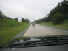
It was raining almost the whole drive out from Richmond and that meant one
thing...MUD!
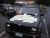
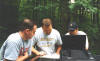
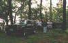
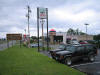
Although we hooked up at Waffle House, it was mobbed. So we decided to do BK
instead and eat in the parking lot while going over the maps. Not only did we
have these (Dale has a thing for maps), but we each had GPS and I had brought
the laptop with all the 24K & 50K Topo maps for the area on it...that's a lot of
maps. 
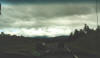
As we headed up Rt33, things started to look a little better...like it might
actually clear up...but it never did...
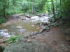
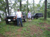
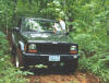
This was the first trail head that we found...the rocks at the entrance seem to
have been deliberatly put there to keep out the riff raff. Problem is, not all
of our club members have the armor to make it over them without serious damage.
Still, it's a legal trail and a small group of us could get in there...
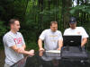
Since Dale's XJ is bone stock, has almost no armor and is his (actually his
wife's) daily driver, we had to figure out another way into the system...time to
bust out the laptop. From left to right that's Brian, Dale and me.
"Dude, I knew we should have turned right at Albuquerque!!!"

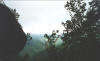
These next few were taken very close to Buzzard Rock, which is just about the
highest point in the area. Unfortuantly, it was really overcast, so this picture
overlooking the valley does not do the view justice...I mean you can't even see
the Blue Ridge montains in the backdrop...

Also from the same spot. That's Dale, Jen and Brian.
...and me and Brian...
Me and Jen on a logging road on the way back down from the top.
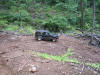
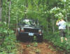
A few shots of a side trail that I decided to go about a 1/2 mile up and then
come back down on. It's much steeper and much narrower than it looks in the pics...I
ended up taking out a small tree on the way up trying to avoid his great
grandfather who jumped out at me....damn trees...
After a busy day of wheelin' and exploring and playing in the mountains...it's
time for some nourishment....
mmmmmm...Mexican Food! 
Over the last few trips
we have learned a lot about our GPS's. The main lesson was just because we have
technology, still be prepared to fall back on the good maps and a good compass.
I know I ain't throwin' out my Delorne anytime soon!
Also, although we did
have problem...the technology didn't exactly fail us; GPS is only as good as the
maps loaded on them. Dale was pretty pissed off that both of our GPS's mislead
us...his missed a waypoint causing us to miss a turn. Once we figured that out
and went back, that turn took us right smack dab into the Strawberry
festival/parade thingie. Since mine only had the basemaps for Standardsville, it
wanted to take us all the way around in a circle to get us to Rapidan...so we
went back to the Delornes. Dale found a way through first and he was "on the
map, !@#$ the GPS!!!" and burned rubber.
However, the tracklogs came in real handy...more handy than anything else about
the GPS actually. When compared to the topo maps, they told us that we had gone
off the logging road (which at the point we deviated had become almost
impossible to pass cause of all the mud...plus neither of us had aired down
making it even more difficult). The ones we were on were not on any
maps...telling us they had all been recently cut. These logging roads are so new
that they do not yet appear on any maps that we've seen.
After all was said and done, it was a good R&D day:
a) We learned a lot about our equipments shortcomings and how to get around
those shortcomings
b) we found a couple of new trails for us to take on future runs
Plus we just had an awesome time, it was a lot of fun.
Here's the
abbreviated version of our track logs: